Some articles explaining the fallacy of "radiometric dating" of soil and rock:
Volcanic lava proving radiometric dating does not work (Andrew Snelling, PhD Geology)
The-fallacies-of-radioactive-dating-of-rocks (Andrew Snelling, PhD Geology)
Radiometric-dating-breakthroughs (Carl Wieland, MD)
Problems with the U - Pb Radioisotope Dating Methods (Dr. Andrew Snelling, PhD Geology)
Little Known Facts About Radiometric Dating (Tas Walker, PhD Mechanical Engineering; BS Earth Science)
Radiometric Dating and the Age of the Earth (Ralph Matthews, PhD Radiation Chemistry)
Diamonds are a Creationist's Best Friend (Jonathan Safarti, PhD Chemistry)
More Bad News for Radiometric Dating (David Plaisted, PhD Computer Science)
Tuesday, March 27, 2018
Catastrophic Geology: Case 14 - Vredefort Impact Crater
 In the area southwest of Johannesburg, South Africa, is evidence of the largest impact crater on the planet. Although the origin of the Vredefort structure has been uncertain for many years, until the 1990's when consensus was reached. The impact feature is only visible from geology mapping information and satellite imagery. The crater has a diameter of 50 miles ! An outer ring is 200 miles in diameter ! A prevailing model is that a 10 km diameter asteroid within the overall asteroid shower of the great catastrophe, punched into the earth, and rebounding rocks thrust up and out forming the inner ring composed of hills of metamorphosed rock (gold bearing quartz and conglomerate rock). As reported by Tas Walker (geologist):
 "The area inside the ring is granitic rock which forms the basement of the area. Before the granite rebounded, it sat more than 20 km beneath the surface. The force of the impact deeply fractured the granite, and partly melted it. Some magma was rich in iron and magnesium and filled the cracks, enveloping chunks (clasts) of broken granite, and solidifying into a black, glassy rock called pseudotachylite (soo-do-tacky-lite). Because it has been found at a number of impact sites around the world it has been taken as evidence for the asteroid [shower] impact. Leeuwkop Quarry near Parys shows magnificient exposures of pseudotachylite enveloping large, rounded chunks of granite."
"Other magma was rich in silica and aluminum. This flowed into other cracks forming a light colored rock called granophyre, which is exposed as a number of long dykes in the area. These dykes and the pattern they form are also evidence for the impact."


Widespread and deep geologic changes occurred within minutes. Not "millions" of years. The asteroid penetrated sedimentary deposits (water borne deposits) and the underlying bedrock. Subsequent rapid sedimentation (the Karro Supergroup geologic formation) occurred after the impact. Tremendous erosion then occurred as the water level receded, forming the Great African planation surface and exposing the Vredefort dome. The patterns of drainage erosion around the dome through the tilted ring of mountains are evidence of receding water, not slow erosion along drainage valleys.
Friday, May 5, 2017
Coquina Limestone
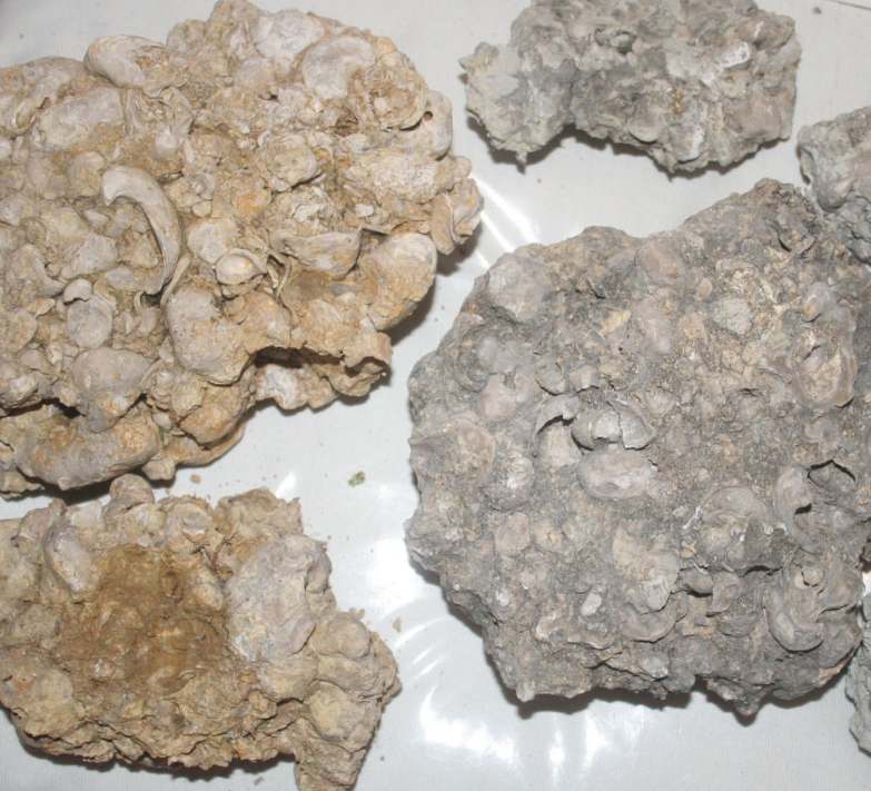
Although rare in Central Texas, "coquina" limestone is occasionally evident, generally as part of the sedimentary deposit categorized as the "Cow Creek Limestone" geologic formation. Although it can be found in other "limestone" deposits. Coquina implies fossil-dense limestone. Limestone implies calcium carbonate rich material, and sea shells are calcium carbonate rich material. Therefore a coquina is a form of limestone. As with most limestone materials, coquina can be a detrital limestone (shell-dense soil transported during deposition) or non-detrital (shell-dense beach buried rapidly in place).
Various terms have been developed to describe fossil-dense limestone, therefore terminology can be confusing or even defined differently be different people. In general terms we might commonly use:
"Coquina": A limestone sedimentary deposit formed predominantly by marine shell animals and sand.
"Coquinite": A stong cemented coquina (rock), likely formed from notable burial under subsequent sedimentary deposits. Lithification by compaction.
"Coquinoid": A coquina where sand is more abundant in the matrix.
"Hash": Fossil hash or shell hash are terms used to described a coquina with notable variable (mixed) animal types and shell condition. High variability and condition of the animals at the time of burial generally implies a high hydraulic energy environment that broke up the sea fauna to produce a bed of random composition.
 The samples at right were identified as coquina (or more likely coquinite) found in Texas, offered for sale on ebay.

This is a photograph of coquina found in Florida. This has the structure of a detrital deposit (deposition from high energy event).
High energy events producing fossil hash could conceivably be from large waves (meteor impact; earthquake) or underwater landslides caused by any number of possible events.
 When a coquina is discovered with relatively intact postmortem shells (split bivalves) and low variability, it might imply rapid burial of a shell-dense beach. Some shell-dense beaches exist around the world including in Australia and the Caribbean. The shells wash ashore and collect over time.

Various terms have been developed to describe fossil-dense limestone, therefore terminology can be confusing or even defined differently be different people. In general terms we might commonly use:
"Coquina": A limestone sedimentary deposit formed predominantly by marine shell animals and sand.
"Coquinite": A stong cemented coquina (rock), likely formed from notable burial under subsequent sedimentary deposits. Lithification by compaction.
"Coquinoid": A coquina where sand is more abundant in the matrix.
"Hash": Fossil hash or shell hash are terms used to described a coquina with notable variable (mixed) animal types and shell condition. High variability and condition of the animals at the time of burial generally implies a high hydraulic energy environment that broke up the sea fauna to produce a bed of random composition.

This is a photograph of coquina found in Florida. This has the structure of a detrital deposit (deposition from high energy event).
High energy events producing fossil hash could conceivably be from large waves (meteor impact; earthquake) or underwater landslides caused by any number of possible events.


Tuesday, February 21, 2017
Catastrophic Geology: Case 13 - Burlingame Canyon
 In 1926, a diversion ditch exposed to relatively high water flowrate and volume produced a 1500-ft long 120-ft deep canyon in just 6 days through hardened fine-grained (silt, clay, fine sand mixtures possibly) and occasionally gravelly, sedimentary deposits characterized as the "Touchet" geologic formation". These deposits are from "slackwater" produced after the massive Missoula flood. The huge canyon exposed uniform thickness beds (layers) of the slackwater deposits, indicative of pulses of flood backwater from the catastrophic flood event. The beds are also characterized as rhythmites or rhythmically bedded material.
  The canyon is in the current Wall Walla river valley in Washington State. The rhythmites are 330 feet thick, indicating the massive nature of the Missoula flood and the geologic consequences of such a catastrophic event.
This is another example of the power of water and the catastrophic impact it can have on geology. The "Touchet" beds were formed from a catastrophic event, and the Burlingame Canyon through them was formed by a catastrophic event. You do not need millions of years to produce the landscape you see around you.
Friday, January 6, 2017
Catastrophic Geology: Case 12 - Rock Erosion
Rock erosion occurs much faster than previously conceived or perceived. Very steep slopes or vertical faces (bluffs) are inherently unstable over time. And no it does not take "millions of years". The rock formations we see today are constantly experiencing rock mass wasting (erosion) due to weathering processes. Catastrophic collapses routinely occur, altering our landscape.
 "London Bridge" on the Australian coastline collapsed in 1990, stranding 2 tourists on the outcrop who had to be rescued by helicopter. Images were presented in the 2015, No. 2 issue of Creation Magazine.

 In 2009, the "Island Arch" collapsed. The rock formations you look at today are not "millions of years old" or exhibits of "timeless eternal looks", they have changed significantly since their initial exposure.
 In 2005, one of the "12 Apostles" suddenly disappeared:

The rate of rock mass wasting observed is one of the many pieces of evidence that refutes the concept that the earth could be "millions of years" old.
Arches National Park in Utah also exhibits rapid rock mass wasting. In 2008 the famed "Wall Arch" collapsed. The famed "Landscape Arch" will collapse at any moment, with some progressive collapses already observed. Since 1970, 43 of the park's arches have collapsed, providing evidence of relatively rapid changes to rock geomorphology.
 "London Bridge" on the Australian coastline collapsed in 1990, stranding 2 tourists on the outcrop who had to be rescued by helicopter. Images were presented in the 2015, No. 2 issue of Creation Magazine.

 In 2005, one of the "12 Apostles" suddenly disappeared:
The rate of rock mass wasting observed is one of the many pieces of evidence that refutes the concept that the earth could be "millions of years" old.
Arches National Park in Utah also exhibits rapid rock mass wasting. In 2008 the famed "Wall Arch" collapsed. The famed "Landscape Arch" will collapse at any moment, with some progressive collapses already observed. Since 1970, 43 of the park's arches have collapsed, providing evidence of relatively rapid changes to rock geomorphology.
Thursday, May 19, 2016
Catastrophic Geology: Case 11
In 2014, a landslide occurred near Collbran, Colorado. The landslide was a debris flow, a conglomeration of soil, rock, and the wooded debris, that travels similar to a liquified sand mass. Some have theorized that vibrations within the mass allow it to travel as a debris flow. The failure was instigated by a rotational global slope instability failure near the top of the mountain, producing a headwall scarp almost 600 feet tall at its maximum height. A cascade of subsequent landslides produced the overall catastrophic landslide that traveled approximately 2.8 miles and killed 3 men.

Heavy rain likely reduced the shear strength along some of the failure plane within fissures in the sedimentary rock mass (shale) and instigated the failure.
A study by a team from the geology department at Colorado Mesa University found that the landslide produced new deposits up to 150 feet thick maximum in a matter of minutes (not millions of years). The new deposit includes rock boulders and buried trees and other organic debris and if subsequently buried could form conglomerate or breccia type rock or resemble a glacial till.
The geology team also observed evidence that the original topography indicated the remnants of previous landslides (ancient slump blocks evident below steeper mountain slope).
Saturday, May 7, 2016
Evidence of Catastrophic Geology: Case 10
Sedimentary deposits such as alluvial terrace deposits (regional flood deposits), debris flows (landslide during flood along river or stream valley), or mud flows (saturated fine-grained soils in a landslide during a flood along a river or stream valley) can produce layers several feet thick in a single event. At Mount Rainer for example in 2006 the Tahoma Creek was subjected to severe flooding, in some places flooding the river valley 400 feet across. Flood flow aggredation deposited 4 feet of granular soil in a single event near the bridge at the photograph below. The level the man is standing at was 4 feet higher than before the flood.

A park geo-scientist reported in a video presentation of the event up to 6 feet of deposition in some areas, and an accumulated 38 feet total aggredation in some areas since 1910. That is a 38-ft thick channelized or wide valley sedimentary deposit stratum or bedded strata in less than 100 years. Although the Tahoma Creek drainage valley is the downstream drainage feature of the local glacier, granular flood deposts can be produced along any river or stream valley where source rock is available upstream where rivers are present through rock geology. "Aggredation" is a term used to describe the accumulation of sediment.
Subscribe to:
Posts (Atom)